A World of Invasive Species in Michigan
By Tina Williams [email protected]
David L. Mackenzie Elementary-Middle School, Detroit, MI
Click on image to download a printable version of this lesson plan
We would greatly appreciate your feedback! Click here to complete a short survey telling us about your experience with this lesson plan.
By Tina Williams [email protected]
David L. Mackenzie Elementary-Middle School, Detroit, MI
Click on image to download a printable version of this lesson plan
We would greatly appreciate your feedback! Click here to complete a short survey telling us about your experience with this lesson plan.
Lesson Overview
Students will learn what invasive species are, how invasive species harm ecosystems, where they come from and circumstances as to how they are introduced to new locations, and preventive measures to slow down their invasion. A large part of the lesson is reading and interpreting the data on maps, showing that invasive species are a world-wide problem, not just a problem in Michigan.
Target Grade & Subject: 6th-8th Grade; Science
Duration: One or two 50-minute periods
Instructional Setting: classroom
Advance Preparation:
https://youtu.be/rtsmacpm0lo
https://youtu.be/-syhod1yx10?t=26
Learning Objectives:
At the end of this lesson, students will be able to:
Michigan Science Performance Expectations Addressed:
SEP: Science & Engineering Practices: Interdependent Relationships in Ecosystems
DCI: Disciplinary Core Ideas: LS4.D Biodiversity & Humans-changes in biodiversity can influence humans’ resources such as food, energy, medicines, as well as ecosystem services that humans rely on
CCC: Cross-Cutting Concepts: 6.SP.B.5 Summarize numerical data sets in relation to their context.
Materials & Quantities Needed per class and per student group
Per class:
Driving Question:
Where do invasive species come from and how do they get to Michigan?
5E Model
ENGAGE: The teacher uses phenomena to introduce the driving question in a way that engages the students’ interest and builds on their prior knowledge. The phenomena should be interesting to students, and explaining it should require understanding core ideas.
Slide 1 of PP: Teacher will ask students what is an invasive species? Take a few answers…go into the first slide and define invasive species. Ask the students, “Who can tell me the name of this invasive species?…click for picture to pop up. The Sea Lamprey picture should grab their attention. Take a few responses and then reveal the correct answer.
Expected prior knowledge: Key concepts students should know before the lesson:
The basic concept of an ecosystem (what it is and what it does)
EXPLORE: The teacher will facilitate the students’ exploration of the question and collection of data.
Display the 3 maps: a) the Great Lakes; b) the United States; and c) the world (scaled down to fit on one sheet). Students can see how invasive species are a local, national, and global problem.
Supporting students during exploration: Questions that the teacher could ask to guide the exploration.
Slide 4 of PP: Ask students, “What could happen if invasive species cause the loss of beneficial native species?” (Answer: depletion of human food supply, loss of jobs for commercial fisherman. Answers will vary.)
Slide 4 of PP: Have students take 1-2 min. to read and examine the cartoon. Then ask students, “Who can tell me what the cartoon is inferencing?” (Answer: how the invasion of invasive species results in the loss of beneficial species-- invasive species are like bullies.)
* Slide 4 of PP: Teacher should define degradation (breakdown) & biodiversity (the variety of life in a specific habitat or ecosystem) while presenting this slide. New vocabulary should be defined as they are presented throughout the lesson.
EXPLAIN: How will the students be expected to explain their data or evidence?
By randomly picking a student to explain to the class what the data on the maps represents.
ELABORATE: How will the teacher facilitate the sharing of student explanations?
Encourage students to explain aloud “why” when given answers or present the evidence they have, allow students to “piggyback” on previous student’s explanations. As maps are being examined, select student(s) to explain to the class what the data on the map is showing, allowing relevant information to be shared by students who have had personal experiences with invasive species, art expression. Teacher will post students’ work around the room.
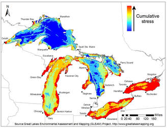
The map of the Great Lakes shows the cumulative impact of 34 stressors, of which invasive species is only one of the stressors that went into creating the map. The scientists who created the map have not published all of the underlying data, but the students can discuss which aspects are most likely to reflect invasive species: For example, the “tracks” across the middle of Lake Superior and along the western edge of Lake Huron are where ships travel to go to Duluth, MN and elsewhere. The harbor in Duluth at the far western end of Lake Superior is where many invasive species first appeared. Zebra mussels were first discovered in Lake Erie and Lake St. Clair (unfortunately, the Great Lakes map completely leaves out Lake St. Clair since it is not a Great Lake). When the students look at the next map, which shows where zebra mussels and quagga mussels have been found, they can see that both zebra mussels and quagga mussels are found in Lake St. Clair and the Detroit River.
The maps of zebra mussels and quagga mussels in the United States could raise questions about 1.Why are only quagga mussels found across most of Lake Michigan (it’s because quagga mussels can live at greater depths than zebra mussels), and 2. how did quagga mussels get to Arizona?
There are TWO world maps about invasive species. The top one is where invasive species are found (that is where they invaded). The bottom one is countries invasive species have come from.
The United States has been invaded by a LOT of invasive species. Students should notice that it is one of the “reddest” countries in the world. Why is that? Where did the invaders come from? How and why?
When the world maps are shown, ask students to identify where specific invasive species originally came from. Some examples from the PowerPoint can be used:
Sea Lamprey: Atlantic Ocean (especially Canadian and United States off-shore areas)
Zebra Mussel: Southwest Russia and Ukraine, originally (Black Sea); they spread across Europe in the 19th Century, so the mussels that invaded the US and Canada in the 1980’s may also have come from the Netherlands or other western Europe countries
Northern Snakehead: Native to China and Korea, these fish have invaded Maryland, Arkansas, possibly some places in Pennsylvania and Ohio. They are not in Michigan but are on a “watch list”
Asian carp: several species have appeared in the United States, including grass carp, bighead carp, and silver carp (these are the ones that jump out of the water when boats go by). Imported from China originally for aquaculture, they escaped into the wild and cause many problems.
The teacher could supplement these with examples of invasive insects like emerald ash borer and invasive plants like phragmites. Additional information about them can be found at https://www.michigan.gov/invasives/
Supporting students during elaboration: Questions to ask to clarify student thinking.
After showing the first two Youtube video clips ( https://www.youtube.com/watch?v=apXUdf1XR-c and
https://youtu.be/rtsmacpm0lo), the teacher says, ‘As you can see, this is a problem in the state of Michigan. Do you all think invasive species only happens in Michigan. Take a few answers, have them explain why. Pass maps out to students and explain that it is a local, national, and worldwide issue.
After showing Youtube clip #3, revisit the maps (PP slide #8,9,10) and pick students to explain the data (one student explanation per map). PP Slide #11-click on link and starting with boaters and anglers and ending with water gardens, briefly describe preventive measures. Under boaters and anglers is a brief youtube video to play, if time allows.
EVALUATE: How will students be assessed and how will the teacher have students apply what they learned?
Independent Work: Students will be required to write 3-5 sentences reflecting on what they have learned about invasive species and create a poster/slogan on the prevention of invasive species, including Sea Lamprey or other invaders of the Great Lakes region.
Supporting students during evaluation: Questions the teacher could ask to tie students’ ideas to the big idea.
Who can name a freshwater system(s) in Michigan that the Sea Lamprey could invade? (Answer: Great Lakes, river system, inland lakes, etc.).
New Vocabulary:
sea lamprey - an eel-shaped freshwater, jawless parasitic fish.
Invasive species - a species that is non-native to the ecosystem.
native species - a species that normally lives and thrives in a particular ecosystem.
Biologist - a person who is an expert in the branch of science concerning living organisms.
biological control - control of a pest by the introduction of a natural enemy or predator
chemical control - chemicals used to kill or inhibit development.
mechanical control - management by way of barriers, trapping, or removal.
Safety Considerations:
Students will be responsible for adhering to the student code of conduct and classroom directives for safety.
Sources:
You Tube Videos:
Invasive Species: Stop the Spread, by Michigan DEQ(EGLE) 7/13/2016
Sea Lamprey in the Great Lakes, Shaw TVSSM: Simon, Paul, Sea Lamprey Control Center 1/8/2016
Blood Sucking Lamprey: River Monsters, 6/6/2013
Powerpoint Presentation: Michigan Invasive Species, https://www.michigan.gov/invasives/ , copyright 2019
Images are used for educational purposes and were obtained via Google images, date copied 2/18/2019
Supporting Materials: PowerPoint presentation and maps
Students will learn what invasive species are, how invasive species harm ecosystems, where they come from and circumstances as to how they are introduced to new locations, and preventive measures to slow down their invasion. A large part of the lesson is reading and interpreting the data on maps, showing that invasive species are a world-wide problem, not just a problem in Michigan.
Target Grade & Subject: 6th-8th Grade; Science
Duration: One or two 50-minute periods
Instructional Setting: classroom
Advance Preparation:
- Review PowerPoint presentation. Also available as pdf.
- Preview websites that will be used:
https://youtu.be/rtsmacpm0lo
https://youtu.be/-syhod1yx10?t=26
- Prepare supplies (markers, sharpened colored pencils, construction paper, pencils, notebook paper, pre-made posters (cut line paper in half, staple it to construction paper (copy paper can be used) and glue sticks (optional). If desired, already have the markers and colored pencils (sharpened) in bundles/zip lock bags so that you can pass out easily to groups or individuals.
- Print maps of invasive species invasions of a) the Great Lakes, b) the United States, and c) the world (scaled down to fit on one sheet).
Learning Objectives:
At the end of this lesson, students will be able to:
- Define invasive species.
- Give example(s) of invasive species in the state of Michigan
- Describe three impacts of Invasive species.
- Name three places invasive species have come from and explain why or how a non-native species might be introduced to a new location.
- Explain three ways to prevent or control invasive species.
Michigan Science Performance Expectations Addressed:
SEP: Science & Engineering Practices: Interdependent Relationships in Ecosystems
DCI: Disciplinary Core Ideas: LS4.D Biodiversity & Humans-changes in biodiversity can influence humans’ resources such as food, energy, medicines, as well as ecosystem services that humans rely on
CCC: Cross-Cutting Concepts: 6.SP.B.5 Summarize numerical data sets in relation to their context.
Materials & Quantities Needed per class and per student group
Per class:
- PowerPoint presentation & access to technology (projector/internet/computer),
- 25 sheets of construction paper (copy paper),
- 10-20 sheets of lined paper,
- pencils, colored pencils, markers, glue sticks,
- printed maps relating to invasive species invasions of: a) the Great Lakes; b) the United States; and c) the world (scaled down to fit on one sheet). Each student will get a copy. Collect at end to reuse with future classes).
Driving Question:
Where do invasive species come from and how do they get to Michigan?
5E Model
ENGAGE: The teacher uses phenomena to introduce the driving question in a way that engages the students’ interest and builds on their prior knowledge. The phenomena should be interesting to students, and explaining it should require understanding core ideas.
Slide 1 of PP: Teacher will ask students what is an invasive species? Take a few answers…go into the first slide and define invasive species. Ask the students, “Who can tell me the name of this invasive species?…click for picture to pop up. The Sea Lamprey picture should grab their attention. Take a few responses and then reveal the correct answer.
Expected prior knowledge: Key concepts students should know before the lesson:
The basic concept of an ecosystem (what it is and what it does)
EXPLORE: The teacher will facilitate the students’ exploration of the question and collection of data.
Display the 3 maps: a) the Great Lakes; b) the United States; and c) the world (scaled down to fit on one sheet). Students can see how invasive species are a local, national, and global problem.
Supporting students during exploration: Questions that the teacher could ask to guide the exploration.
Slide 4 of PP: Ask students, “What could happen if invasive species cause the loss of beneficial native species?” (Answer: depletion of human food supply, loss of jobs for commercial fisherman. Answers will vary.)
Slide 4 of PP: Have students take 1-2 min. to read and examine the cartoon. Then ask students, “Who can tell me what the cartoon is inferencing?” (Answer: how the invasion of invasive species results in the loss of beneficial species-- invasive species are like bullies.)
* Slide 4 of PP: Teacher should define degradation (breakdown) & biodiversity (the variety of life in a specific habitat or ecosystem) while presenting this slide. New vocabulary should be defined as they are presented throughout the lesson.
EXPLAIN: How will the students be expected to explain their data or evidence?
By randomly picking a student to explain to the class what the data on the maps represents.
ELABORATE: How will the teacher facilitate the sharing of student explanations?
Encourage students to explain aloud “why” when given answers or present the evidence they have, allow students to “piggyback” on previous student’s explanations. As maps are being examined, select student(s) to explain to the class what the data on the map is showing, allowing relevant information to be shared by students who have had personal experiences with invasive species, art expression. Teacher will post students’ work around the room.
The map of the Great Lakes shows the cumulative impact of 34 stressors, of which invasive species is only one of the stressors that went into creating the map. The scientists who created the map have not published all of the underlying data, but the students can discuss which aspects are most likely to reflect invasive species: For example, the “tracks” across the middle of Lake Superior and along the western edge of Lake Huron are where ships travel to go to Duluth, MN and elsewhere. The harbor in Duluth at the far western end of Lake Superior is where many invasive species first appeared. Zebra mussels were first discovered in Lake Erie and Lake St. Clair (unfortunately, the Great Lakes map completely leaves out Lake St. Clair since it is not a Great Lake). When the students look at the next map, which shows where zebra mussels and quagga mussels have been found, they can see that both zebra mussels and quagga mussels are found in Lake St. Clair and the Detroit River.
The maps of zebra mussels and quagga mussels in the United States could raise questions about 1.Why are only quagga mussels found across most of Lake Michigan (it’s because quagga mussels can live at greater depths than zebra mussels), and 2. how did quagga mussels get to Arizona?
There are TWO world maps about invasive species. The top one is where invasive species are found (that is where they invaded). The bottom one is countries invasive species have come from.
The United States has been invaded by a LOT of invasive species. Students should notice that it is one of the “reddest” countries in the world. Why is that? Where did the invaders come from? How and why?
When the world maps are shown, ask students to identify where specific invasive species originally came from. Some examples from the PowerPoint can be used:
Sea Lamprey: Atlantic Ocean (especially Canadian and United States off-shore areas)
Zebra Mussel: Southwest Russia and Ukraine, originally (Black Sea); they spread across Europe in the 19th Century, so the mussels that invaded the US and Canada in the 1980’s may also have come from the Netherlands or other western Europe countries
Northern Snakehead: Native to China and Korea, these fish have invaded Maryland, Arkansas, possibly some places in Pennsylvania and Ohio. They are not in Michigan but are on a “watch list”
Asian carp: several species have appeared in the United States, including grass carp, bighead carp, and silver carp (these are the ones that jump out of the water when boats go by). Imported from China originally for aquaculture, they escaped into the wild and cause many problems.
The teacher could supplement these with examples of invasive insects like emerald ash borer and invasive plants like phragmites. Additional information about them can be found at https://www.michigan.gov/invasives/
Supporting students during elaboration: Questions to ask to clarify student thinking.
After showing the first two Youtube video clips ( https://www.youtube.com/watch?v=apXUdf1XR-c and
https://youtu.be/rtsmacpm0lo), the teacher says, ‘As you can see, this is a problem in the state of Michigan. Do you all think invasive species only happens in Michigan. Take a few answers, have them explain why. Pass maps out to students and explain that it is a local, national, and worldwide issue.
After showing Youtube clip #3, revisit the maps (PP slide #8,9,10) and pick students to explain the data (one student explanation per map). PP Slide #11-click on link and starting with boaters and anglers and ending with water gardens, briefly describe preventive measures. Under boaters and anglers is a brief youtube video to play, if time allows.
EVALUATE: How will students be assessed and how will the teacher have students apply what they learned?
Independent Work: Students will be required to write 3-5 sentences reflecting on what they have learned about invasive species and create a poster/slogan on the prevention of invasive species, including Sea Lamprey or other invaders of the Great Lakes region.
Supporting students during evaluation: Questions the teacher could ask to tie students’ ideas to the big idea.
Who can name a freshwater system(s) in Michigan that the Sea Lamprey could invade? (Answer: Great Lakes, river system, inland lakes, etc.).
New Vocabulary:
sea lamprey - an eel-shaped freshwater, jawless parasitic fish.
Invasive species - a species that is non-native to the ecosystem.
native species - a species that normally lives and thrives in a particular ecosystem.
Biologist - a person who is an expert in the branch of science concerning living organisms.
biological control - control of a pest by the introduction of a natural enemy or predator
chemical control - chemicals used to kill or inhibit development.
mechanical control - management by way of barriers, trapping, or removal.
Safety Considerations:
Students will be responsible for adhering to the student code of conduct and classroom directives for safety.
Sources:
You Tube Videos:
Invasive Species: Stop the Spread, by Michigan DEQ(EGLE) 7/13/2016
Sea Lamprey in the Great Lakes, Shaw TVSSM: Simon, Paul, Sea Lamprey Control Center 1/8/2016
Blood Sucking Lamprey: River Monsters, 6/6/2013
Powerpoint Presentation: Michigan Invasive Species, https://www.michigan.gov/invasives/ , copyright 2019
Images are used for educational purposes and were obtained via Google images, date copied 2/18/2019
Supporting Materials: PowerPoint presentation and maps

New lesson plan ideas are welcome and will be uploaded as they are received and approved.
For submitting lesson plans about invasive species, send inquiry to jeffram(at)gmail.com
For submitting lesson plans about science and science careers, send inquiry to jchadde(at)mtu.edu
The DPSCD lesson plan template should be used for lesson plan submissions by all DPSCD teachers
Lesson plan ideas from other web sites:
From Pennsylvania Sea Grant: 10 lesson plans about interactions of invasive species, biodiversity, and climate change
Creation of the above page of educational resources was funded in part by the Michigan Invasive Species Grant Program through the Departments of Natural Resources, Environmental Quality, and Agricultural and Rural Development.
This material is also based upon work supported by the National Science Foundation under Grant No. 1614187.
Any opinions, findings, and conclusions or recommendations expressed in this material are those of the authors and do not necessarily reflect the views of the National Science Foundation.